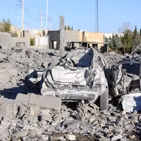
Satellite imagery shows scale of destruction after Iran port explosion
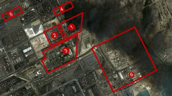
Satellite images obtained by Iran International show the aftermath of the April 26 explosion over a 50-hectare area at Rajaei port in Bandar Abbas, southern Iran.
Satellite images obtained by Iran International show the aftermath of the April 26 explosion over a 50-hectare area at Rajaei port in Bandar Abbas, southern Iran.
The explosion which has devastated Rajaei port, the country's largest container port, has halted more than half of the country's nominal loading and unloading capacity.
The satellite images reveal that the Sina yard, the blast's epicenter which could hold between 12,000 and 20,000 twenty-foot containers, has been completely destroyed.
The area is operated by the US-sanctioned Sina Marine and Port Services, a subsidiary of the Mostazafan Foundation.
The foundation, a multi-billion-dollar conglomerate also sanctioned by the United States, is controlled by Supreme Leader Ali Khamenei and has close ties to the Islamic Revolutionary Guard Corps (IRGC).
Some images are partly obscured due to the massive smoke caused by the blast.
1- Sina yard: 15 hectares
Satellite imagery shows that Sina yard, covering around 15 hectares, has been entirely leveled. Shattered containers are clearly visible in the images. The yard lies approximately 800 meters from the exit and gate control and about 1,400 meters from the first dock.
The administrative building of the Sina Marine and Port Services Development Company, located on the northwestern side of the yard, has been completely demolished.
2- Khazar Qeshm Company: 10 hectares
To the east of the Sina yard lies the Khazar Qeshm Company area, covering 10 hectares, which has also been almost completely destroyed. The company’s warehouse roof, about 500 meters from the explosion’s epicenter, has completely collapsed.
3- Rajaei port customs office: 5 hectares
South of the Sina yard are the administrative buildings of Rajaei port. Satellite images show that destruction extends up to 300 meters into the parking area.This zone had been evacuated, and scattered debris is visible.
Images show that the roof of a building 400 meters from the blast center has also collapsed in the administrative area.
4- Onik area: 500 meters from blast
Explosion damage is visible 500 meters north of the Sina yard, in the Onik yard.
5- Hazardous materials zone: 1,300 meters away
According to a map released by Rajaei port, the designated area for storing hazardous materials—marked as zone 5—is about 1,300 meters from the explosion center. No destruction is observed in this hazardous materials zone.
6- Petroleum product storage tanks
The distance from the Sina premises, the site of the explosion, to the petroleum product storage area and tanks marked as No. 6 in the image is only about 1,000 meters. Had the fire spread to this area, the scale of the explosion could have been far more catastrophic.