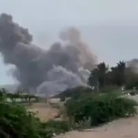
The locations monitored were in Saudi Arabia, United Arab Emirates, Iraq, Kuwait, Oman, Jordan, Bahrain and Djibouti, and included US military bases as well as some infrastructure, the report said.
The satellite, known as TEE-01B, was acquired by the aerospace force of the Islamic Revolutionary Guards in late 2024 after it was launched from China.
“This satellite is clearly being used for military purposes, as it is being run by the IRGC’s Aerospace Force and not Iran’s civilian space program,” Nicole Grajewski, an expert on Iran at Sciences Po university, told the Financial Times.
Time-stamped coordinate lists, satellite imagery and orbital analysis showed Iranian commanders used the satellite to monitor key US military sites. The images were taken in March before and after drone and missile strikes on those locations.
“Iran really needs this foreign-provided capability during this war, as it allows the IRGC to identify targets ahead of time and check the success of its strikes,” Grajewski added.
The report said the satellite took images of Prince Sultan Air Base in Saudi Arabia, among other locations, on March 13, 14 and 15, and on March 14, US President Donald Trump said US aircraft at the base had been hit, with five Air Force refueling planes damaged.
China’s foreign ministry on Wednesday rejected the report as untrue.
“Recently, some forces have fabricated rumors and sought to link them to China,” the ministry said in a statement to Reuters.
“China firmly opposes such practices driven by ulterior motives,” it added.